Overview of the Run and Card Stops
Check back here for last minute updates
Card Stops In Order + Bonus Stop
Base Run is approximately 78 Miles
- The Marina at Manhattan Harbour (Start)
- mm 467
- Northernmost Point in Kentucky (Flotilla)
- mm 486
- Rising Sun Indiana, Floating Card Stop
- mm 506
- Lighthouse Point Marina (Lunch and Fuel Stop)
- mm 494
- Ludlow Bromley Yacht Club (LBYC) - Rolling Stop (no Tie up)
- mm 474
- The Marina at Manhattan Harbour (END)
- mm 467
Bonus Stop Run is approximately 126 Miles Round Trip
** Bonus Stop for the serious Runner's
In the map below, select the icon in the corner to expand the map icon glossary

This map outlines the various stops. The map is interactive so please pick a point if you need more information.
Water Safety
- We REQUIRE everyone to wear a USCG Approved life vest, ultimately the event is at your own risk, so the responsibility is of the boat captain to operate in a safe manner in compliance with all local, state and federal laws.
- It is REQUIRED that everyone operating their watercraft wear the Safety Tether (kill switch)
- All safety guidelines by the State of OH, KY, IN as well as USCG should be understood and followed, even if not explicit in this safety notice or any other implied directions.
- As always, use good judgment and be aware of those around you. You are responsible for your watercraft, its operation, including your wake.
- You must “wet sign” the release form in order to participate.
- We provide the route as a guideline and not an explicit rule. At any point, should the water conditions exceed your ability as pilot/captain or your watercraft’s ability to safely operate, take necessary action in a safe manner that is considerate of your crew and others on the waterway to seek safety.
- Be aware that commercial traffic including water ferries have the right of way.
- Be aware that the river is a public waterway and you may encounter others who are not participating or have been made aware of this event.
- It is incumbent upon the Captain of the craft to ensure the safety of the occupants and those surrounding them at all times.
Important
Contacts
- Any Emergency Services
- Phone 911 *please note your river location
- Boone County Water Rescue
- Phone: (859) 371-1234
- Manhattan Harbor (Todd Crawford)
- Phone (859) 468-1471
- Lighthouse Point Yacht Club
- Phone (812) 926-4505
Docking at
Manhattan Harbour
Dock space has been reserved for Rock the River Participants (ONLY)
Upon launching or arrival
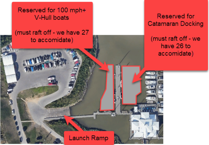
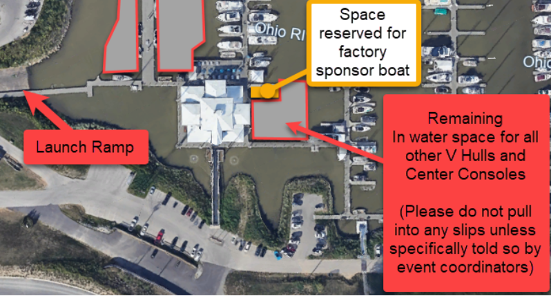
- Please be aware of the dock plan. Transient dock will be organized by class to assist in a more organized departure. Note that certain dock spaces will be reserved, please be aware.
Overnight Docking
- We have arranged for reserved overnight docking on the Transient docks
Arriving at the Marina
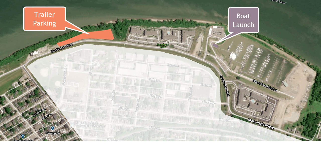
The Map Overview below will indicate where the ramp is located as well as where Truck and Trailer parking will be allocated for this event. Please do not park in member areas or decide to "make a spot" in the grass.
We will be providing shuttle service via golf carts upon request (talk to the ramp personnel )

Docking at the Marina


We are also enforcing this so that when we release boats from the marina, they will be released in speed classes. This way, there is a safe and orderly exit where we can get the fastest boats out first to minimize a chaotic passing scenario through the areas of Cincinnati. This section of the river approaches fast from the marina exit. It is also the narrowest and most congested, along with several bridges that must be avoided. This format has been adopted to eliminate idling in the river channel, waiting for a clear to leave signal.
